This section of our trip gives us lots of time on iconic, outback, unsealed roads. In fact more than we’d originally bargained for, as it turns out.
The map of this section crosses three states and a distance of 2745 kms. It took us 10 days; excluding the backtrack of 2 days and 314 kms for the tire issue and including our 2 days in Alice.We thought we’d said ‘goodbye’ to Laverton and Leonora (small towns in WA) when we headed up the Great Central Road (GCR) on a cloudy, windy day.
The GCR is part of the Outback Way, Australia’s longest shortcut. The Outback Way provides the third strategic road link across the continent, linking Laverton WA to Winton, Queensland. It is 2700 kms, 1300 kms of unsealed road and 1400 kms of sealed road. This project opens up new tourist routes, new transport routes (it reduces the east west connection by 1600kms), better access for mining and pastoral interests and improved access for remote indigenous communities. So its been on Dick’s wish list for a while.
After two hours we pulled over to air down (reduce the tire pressure to make it more comfortable and better for the tires on rough roads) and found a rear flat tire and it was sprinkling with rain. This was a bad hole and not repairable by Dick, so 2.5 hours after we stopped we turned around and headed back towards Leonora.We needed to stop at a free camp on the way back and then ended up back in the caravan park in Leonora for one night. This is what happens when you get the last spot in a caravan park – between two long term residents! Made me glad we don’t have to live in a caravan park in remote WA. That said we had no trouble there.
We got the tire repaired (it was a large hole) and we bought a second spare which now lives in the shower, so two days later we again started on the GCR. Sometimes things have a way of working out. As it turns out Helen and Anthony’s twins were born the day we first started the GCR, so the fact that we were back in town for two nights meant we could have more time speaking with Helen on the phone and seeing photos of the twins.
Different views along the GCR. In reality it was not a bad road, some variation in the landscape and just a lot of driving; 1126 kms (700 miles) to Uluru..Counting our first night going back to Leonora, we had four free camps along the GCR. We could have stayed at some roadhouse caravan parks, but preferred these locations instead – no barbed wire around security fences! The Warburton Roadhouse caravan park featured this sign: “For your peace of mind: We lock the front gate about 7pm thru to 7am. Warburton is no different to any other place on this planet. Sometimes bad things happen.”In the three days along the GCR, we saw way more wrecked cars than anything else.On the second day we saw 3 cars, 2 road graders and about 15 camels. This is a gif of camels running along the road. Apart from the camels on the GCR, we saw one dingo and one majestic black horse.
The one stop I wanted to do on the GCR was to visit the Tjulyuru Exhibition Space and Gallery at Warburton. It is an impressive building and showcases the most substantial collection of Aboriginal art in the country under the direct ownership and control of Aboriginal people. There were lots of huge, attractive paintings in the gallery as well as glass works and weavings. The shop also had a good array of paintings, glassworks and other items to purchase. AND – we were the only ones there. They opened the gallery for us. I suspect lack of promotion and signage contributes to the lack of interest from passers by. No photos to show as it was forbidden to take photos anywhere in Warburton. However in the shop they did let me facetime with Amy so I could show her some paintings I had thought she might like for her birthday. She picked one. Unusual but quite a good way to shop in a gallery.
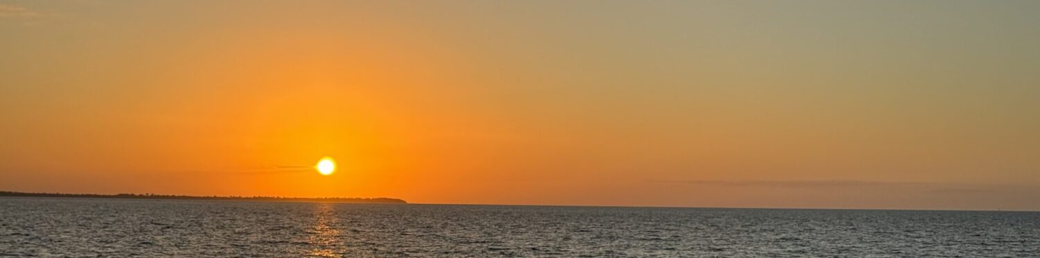
The final stop we did on the GCR was to visit Lasseter’s Cave and learn the story of his search for gold and his demise, as outlined in this sign..Not a very big cave and not an auspiscious monument.The first sight we saw as we crossed into the Northern Territory (NT) was Kata Tjuta (formerly known as The Olgas). No one and no signs at the border, but we were ready with all our passes. Kata Tjuta is a group of 36 large domed rock formations spread over more than 20 kilometers. It remains deeply spiritual and sacred to the local Anangu people who have lived here for more than 22,000 years.The top rock is Uluru (16 kms driving around the base) and the bottom rock is Mt Augustus (49 kms driving around the base). Mt Augustus is twice the size of Uluru and advertised as the largest rock in the world. We visited it recently so I was keen to see how the two of them compared. After we passed Kata Tjuta we saw Uluru from the distance as we headed straight for the campground at Yulara (formerly known as Ayers Rock Resort), the only place we could camp in that area.The Valley of the Winds walk at Kata Tjuta was the one walk we had not done five years ago, so our plan was to do this walk. We were looking forward to doing it, and we were not disappointed.It was a warm/hot, beautiful sunny day for our walk. We did the full circuit and hoped we could manage the grade 4 walk.The rocks were stunning during the early afternoon light. Didn’t see them at sunset but they are supposed to be amazing then.It wasn’t an easy walk in the heat but certainly worth doing.Smiles as we were both pleased that we managed to do the walk without incident. We did 9kms in about 4 hours.To complete our brief Uluru experience, we drove out for the sunset viewing. Previously we had done the walk around Uluru. This time we firstly we drove around Uluru and then we drove to the classic sunset viewing spot.Just before sunset the colors are amazing. Lots of people out having a look, even though the village is much quieter and suffering from lack of overseas visitors
As per our plan Yulara was a good three day stop for supplies, laundry, a couple of meals out, a good walk and a sunset viewing of Uluru. All was going well, until just before we drove out of Yulara heading for South Australia, we heard that all of South Australia was in a 7 day lockdown. During the 246 km drive to the Sturt Highway, we debated our options – and decided in the end that we did not want to do a 7 day lockdown on the SA border. So we turned north at the Sturt Highway (instead of south) and headed for Alice Springs and a Queensland route home.
On the way to Alice Springs we camped at Rainbow Valley, an old favorite camp spot. Just arrived in time for me to get one sunset photo. The light in Central Australia really works magic on the rock formations. Such a difference in this place during the day and at sunset.Getting into Alice felt a bit like coming home – checked back into the Big 4 caravan park (where we spent many weeks in 2018), got to shop for groceries in my favorite supermarket (Woolworths), and got our second Covid shots, Dick got a blood test, and we went out for dinner with Geoff and Vicki, friends who had just arrived in Alice that day. We only had two nights there as we were on a mission to get closer to NSW. Not our most scenic camp spot but we did have our own toilet and shower!Dick has wanted to do The Plenty Highway for ages. So in spite of my misgivings about the road we decided to save 500 kms and give it a go. It was busier than the Great Central Highway and was a better road, with lots of sealed road along the 745 kms to Boulia, Queensland.After finishing all the jobs for travel, we left Alice before 10am and got to our stop at Jervois Station before 3pm. Had a nice camp near a dry riverbed and had time for a uke practice.VIEWS OF THE PLENTY HIGHWAY – notice any similarities?? Actually the road was not too bad.Most people talk about the perils of the bull dust (see above) on the Plenty Hwy, but Belle just ploughed on through it like it wasn’t there. We think the low tire pressure helped and also the hard work of the road crews. Throughout this trip we’ve seen a lot of roadwork being done on most of the unsealed roads.Again we did not see many animals on this road; some cattle and many eagles. The eagles were generally eating roadkill on the road. Interesting that through this whole trip we have not seen many dead animals by the side of the road. In the past we have seen lots of dead and alive kangaroos. Perhaps numbers are down because of the drought??Contemplating a long driving day, we got fuel and left camp just after 9am. Fortunately it was an uneventful day – road had some corrugations and bull dust but was not as bad as expected. As we passed the next regular camping spot, Tobermory Station at around 1pm, we decided to push on. Got into a caravan park in Boulia just before dark at 6pm, which finished our time on the Plenty Highway..
Given the uncertain Covid situation, we know we are travelling through Queensland to get home but the route is not yet decided and will probably change a few times as we work out our timing for a return to Sydney.
As we left Broome we knew we were heading for the Great Central Road which crosses the Gibson Desert in central east WA. We didn’t know if we’d see much along the way, BUT of course we did, and we learned a lot about the history, landforms and people of this part of WA.
This map covers the places we visited in this blog post.80 Mile Beach was our first stop, and we arrived in time to have a restful afternoon.Our friends, Neil and Suzanne, arrived shortly after us so we all did a 5km walk on the beach at sunset. We met them on a hike in the NT on 25/5 and unplanned we ended up camping with them at Keep River NP, Kununurra, El Questro, Windjana; plus we bumped into them in Broome. They were good company and we enjoyed our times together. Our paths diverged after this point (26/6).It was our last beach stop in this trip and a nice place to have a rest day and do a long drive along the beach.
Our next mission was a service for Belle at Toyota in Port Hedland. Unusually for us we left camp just after 7am and got Belle dropped off by 7:15am. After breakfast out and a stop at the Tourist Info, we picked up Belle and drove out of town by 11:40am. Port Hedland did not look like a place to stay for long – very industrial. Heading inland to Tom Price we mostly saw roadtrains on the road – ALL DAY.
After free camping at Tom Price (the caravan park was full and turned us away) and on another long driving day, we met a family who had a flat tire. Dick lent them some boards to put under their jack and used our compressor to pump up one of their tires. The guy was very grateful and gave Dick a 6 pack of beer as a thank you. A few hours later when we camped for the night, alongside the road, we noticed we had a flat tire. In the morning Dick managed to repair it (so that we could keep our spare in reserve), using his tire repair kit than had not been used before. He did a good job and it lasted 6 days until we got to a tire repair shop in Meekatherra.We drove 1026 kms from Port Hedland to Mount Augustus over 3 days and didn’t see much along the way; some feral donkeys, lots of mines, road trains and long straight roads.This is Mt Augustus, twice the size of Uluru and the largest rock in the world! This ‘island mountain’ (inselberg) rises 715m out of the plain. Burringurrah is the aboriginal name for Mt Augustus, and for the national park. The aboriginal legend is that Burringurrah, a young aboriginal boy was undergoing his initiation into manhood and ran away, breaking tribal law. Tribesmen pursued him, speared and beat him. He collapsed and died there and Mt Augustus represents his final resting pose.SUNRISE AND SUNSET FROM OUR CAMP. We had glorious views of Mt Augustus.Its a 49 km circuit around the rock and the park features lots of walks from easy to Class 5 -challenging. We did the 3 hour, 5 km walk to Edney’s lookout. It’s the walk for people who want views but won’t be doing the 12 km summit trail (12 km’s, 5-9 hours return). We are both happy we got to the top of this peak and enjoyed good views without any incidents.It was a big rock scramble to get to Flintstone Rock, which Dick is laying under to photograph engravings by aboriginal people.This is a selection of the delicate flowers we saw on the walks in Mt Augustus NP.Cattle Pool (Goolinee) is a permanent pool near Mount Augustus on the Lyons River. Beautiful river gums and lots of birds. I included a copy of the sign to illustrate how the place names are gradually being changed over to the aboriginal names throughout this park and all the others we have visited. After a final visit to a lookout, we left this park and would certainly recommend it, although its a long drive from anywhere to get here.After a long, boring driving day to Meekatherra, we were rewarded with a stunning sunset at our free camp. Realising that Meekatherra was the biggest town we’d be in for a long time, we spent another day at the Meekatherra caravan park so we could be first in line at the tire repair place on Monday morning. Made it there by 7:15, he opened at 7:30 and had our tire repaired by 8am.As I was wandering around Meekatherra, I got invited to the flag raising ceremony. It was low key and interesting and afterward the community put on coffee and sandwiches and a few people invited me to join that also. Inclusivity seems to be an important part of aboriginal culture. Everyone here was friendly and welcoming. On the other hand, the whole town is full of fences, some with barbed wire on top and security is a big issue. Hard to reconcile …………Next stop was Wiluna, start of both the Canning Stock Route and the Gunbarrel Highway, two 4 WD adventure trails I never want to do. We did go to No 1 well on the Canning Stock Route, on our way to a free camp, so I got photos of the signs wishing people well on the track and welcoming them back.This ‘Last of the Nomads’ statute in Wiluna depicts Warri and Yatungka, who met in the 1930’s and fell in love but tribal law forbade them from marrying because they were the wrong match according to ‘skin group’ law. The consequences of breaking this law would have resulted in severe injury or death so they ran away together in the middle of the night, They lived together in country, in isolation, until 1977. They had three children, one died, During a severe drought in 1977, the elders worried about them and asked for help to find them. After several weeks a search party found them in the Gibson desert, near starvation. They agreed to come into Wiluna, although still feared punishment, but the elders had forgiven them. Both died in Wiluna in 1979 and their deaths marked the end of a tribal lifestyle that stretches back over 40,000 years. To me, this is a true love story as well as an amazing survival story.
The town of Leonora was a pleasant surprise. We got very helpful information from the Visitor Center, good grocery selections and a bonus Indian dinner (twice). The big attraction is Gwalia, a living ghost town and museum, on the edge of a working open cut gold mine 3 kms from Leonora.
This was the open cut gold mine, incongruously placed right beside Hoover House which Herbert Hoover designed and had built in when he was a 24 year old mining engineer working as the mine manager. He went on to become the 31st President of the USA. It is now a luxury B&B and we could have slept in Hoover’s bed for $190/night.This chart outlines the history of the gold mine. Gold was discovered in 1896 in the ‘Sons of Gwalia’ reef by Welsh miners. Gwalia is one of the Welsh poetic names for Wales. 500 men were employed at the mine in 1899.In addition to having coffee in Hoover House, looking in all the rooms there, we had a good look around the museum, which largely consisted of lots of old mining equipment, Dick is looking at the steam winder and the headframe.However he got really excited when he saw this little beauty. Its a lathe for cutting metal into particular shapes AND Dick worked on one very similar to this when he was 15 and working in his father’s business.The living ghost town of Gwalia has been lovingly restored by countless volunteers over the years, and funded by various government heritage grants. 15-20 people still live there. We had a quick look around just before dark.We’d heard about statutes at Lake Ballard so decided to check it out, as it was almost on the way. Had no idea of the scale of this exhibition called Inside Australia’ by Anthony Gormley, an internationally renowned artist from the UK. The exhibition of 51 statutes was commissioned to mark the 50th Anniversary of the Perth International Arts Festival in 2003.
The 51 statutes are based on body scans of inhabitants of the small town of Menzies. Each statute is based on a digital scan of the naked body in three dimensions. Then the body volume is reduced by 2/3’s but the height remains the same. The result is called an ‘insider’.It was fun visiting with all the statutes and we did refrain from any disrespectful touching!We had two sessions walking on the salt lake checking out the statutes; one afternoon and one morning. As you can see here, it was a muddy walk due to recent rain. It would have been nice if the salt lake was in its normal dry state, presenting the statutes against a white background, but we still enjoyed the experience.This little guy was kind of cute. We have been told that many of the inhabitants are able to recognise their own statute.This shows the size and the hill in the background. We thought many of the statutes looked similar but the artist maintains each ‘Insider’ is unique and each reveals the passage of that person’s life.Dick was very happy when he got to the top of that hill, and we enjoyed the views!This sunset photo starts to give the sense of what the artist was getting at when he said the salt lake was ‘absolutely magic’ and the figures are ‘markers in a vast space’. It is quite amazing to see such an exhibition in this remote location. We managed to see 27 of the 51 statutes and walked about 9kms in the process.We camped at The Terraces, a 75 km long line of breakaways near Leonora. This is land where the hard top remains and forms a mesa but erosion of the softer rock and soil forms a steep ‘breakaway’. Quite a common landform in Aus.Of course we climbed up the breakaway and had a look around. In these photos Dick is taking me on the top of the breakaway and I took one of him down at the road. After this we start out on the Great Central Road.