Our next stop was Adel’s Grove, named after a French botanist, Albert De Lestang, who was commissioned by the government to experiment growing tropical trees & fruits in the 1930’s. By 1939 he had over 1000 different species and it was a most beautiful botanic garden. In the early 1950’s it was burnt out and subsequent owners have not continued the botanical aspect of the Grove. We were camping in ‘The Grove’ area, next to Lawn Hill Creek and it is still an impressive grove with lots of tall trees and exotic foliage. The reason to stop here is to visit Lawn Hill National Park (NP), now known as Boodjamulla NP, after the rainbow serpent who created the gorge and all the animals in the Dreamtime. It is a 10 km drive to the NP and we spent the afternoon canoeing through the Lawn Hill Gorge, even did the portage and canoed through the Upper Gorge. It was quite magical since the lush tropical vegetation (ie Livstonia Palms, figs, pandamus etc) are remnants of the ancient rainforest that covered the Gulf Savannah millions of years ago. The gorges have sheer 60 m (200 foot) sandstone walls and beautiful clear green water. Finished the day with a drink at our neighbors campfire. Returned the next day to do the 8km Upper Gorge Walk which was stunning – great variety of terrain, 3 fabulous lookouts, a swim at the falls and a beautiful sunny day. We walked all along the tops of the gorges we canoed through the day before and got a much better perspective of the gorge system and the surrounding area. Walking along the gorge beside the high red cliffs and amongst the ferns and palms was very special, and we were disappointed that we didn’t have time to do more walks there. Met another couple, Ken and Roz,with an Explorer Motorhome like ours, so had some great conversations with them before and after our walk.
Travelling in the outback its good to stay flexible, as we found out again, when we turned up at Hells Gate Roadhouse at 1pm to get fuel and were greeted with a sign advising they were out of diesel. So we had lunch in the roadhouse, one of the nicest we’ve come across and one where we actually were happy to eat the food. Hells Gate takes its name from the days when the police escorted the drovers and pastoralists to the Hells Gate pass on the NT border and then they were on their own. We waited until 4pm when the fuel truck arrived and we were able to continue on. Could have stayed there as it seemed good but we wanted to visit a free camp 30 km down the road and we were glad we did. Stayed at Hann Creek Billabong on our own and sat outside with a beer watching about 40 different bird species flitting around the billabong – very pleasant! And the sunrise was also special. Funny for us to see a sunrise but the 6 am alarm is becoming a habit (maybe we are turning into grey nomads after all). That stop marked the last overnight in Queensland and 10,000 kms so far on this trip.
The view of Lawn Hill Creek beside our campsite at Adel’s Grove
Canoeing in Lawn Hill / Bodjamulla NP Beautiful red cliffs along the lower gorge
Innarroo Falls, site of the portage and swimming place Dick portaging the canoe to the Upper Gorge Canoeing in the Upper Gorge Beautiful water lillies in the gorge More water lillies
A beautiful peaceful place at the top of the gorge The beginning of the gorge and where we turned around
It was such a beautiful canoe trip And we even got very close to a cormorant
Dick made me hold my shirt up for a sail on the paddle back (not very effective) The early part of the walk around the gorge
Looking down on the upper gorge, and a special spot for lunch
Walking between the red cliffs and the clear green water Swimming back at the waterfalls A refreshing dip on a hot walking day!
Another lookout and another view of the upper and lower gorges
The last lookout for the 8km walk, one of our highlights The final climb down
End of day catchup with another Explorer MH! Dick heading into the roadhouse
Not the sign you want to see!! Our camp spot at Hann Creek Billabong Sunrise over the billabong
We took advantage of an extra day in Cooktown to catch up on what we missed on our first visit, including a walk up to the first lookout on Mt Cook and a visit to Keatings Lagoon – lots of water lilies but no birds to be seen. Someone had parked in front of the croc warning sign so we inadvertantly got too close to the water! We had a look at the lichen-blackened slopes at Black Mtn lookout before having lunch at the historic Lions Den Hotel, an iconic pub built in 1875. The highlight of the day was stopping at Trevethan Falls, which were very hard to find, 12.7km’s in on a dirt road with a 500meter hike/climb/rock scramble to get to the falls. They were stunning and we marvel at how often we find these hard to find, stunning places with no signs, generally no one else there and quite special places to see; like this waterfall. Back in Cooktown we got fuel and as it happened the car wash was almost next door so we (Dick) gave the van a much needed wash and it looked like new (almost!). Many of you have commented on the dirty state of our van but we do wash it when we can!
For our drive to Wonga Beach via the Bloomfield Track, Cape Tribulation and the Daintree we left at 8:41(an early start for us). Met an interesting fellow, Ross Franzi – artist, conservationist, builder and engineer; at his Black Cockatoo Gallery, where he is currently building a helicopter and also runs an animal rescue/refuge. He was impressive and his art was very good. We stopped to look at Weary Bay beach before clambering over rocks for 300 meters to see the Bloomfield waterfall. Also visited the Wugal Wugal Art & Cultural centre who were selling traditional dot painting artworks and nice jewellery made by local aborginals from bush nuts and seeds. From there we drove the Bloomfield Track (4WD so we aired down) through the Daintree Rainforest to Cape Tribulation. Road was narrow and windy but not too bad, considering where we had been on the Cape. Managed a walk on Cape Tribulation beach which was nice but too many people!! Spent an hour at the Daintree Discovery Centre learning about the rainforest flora and fauna and visiting its different levels via aerial walkways. They even had life size dinosaurs on display to show the link between their decline and climate change. Took the Daintree River Ferry and ended up at the ‘Wonga Beach Resort’, aka home of our friends Chris and Christine, where we again enjoyed a lovely few days of R&R, plus the mandatory clean up and stock up jobs. Booked the Lestervan in for a 40,000 km service so enjoyed a day in Cairns and then also had a day in Port Douglas with Chris and Christine. I hated to leave as we had such a nice time with them in Wonga Beach.
On the way to the Atherton Tableland we stopped at Mossman Gorge, but found it very commercial and crowded so didn’t stay long. At Mareeba we visited the Tourist Info Centre which has an excellant museum and nice coffee shop so we had lunch there and checked out all the displays. Lots of great fruit and veg stalls in the Atherton Tablelands which looks very green and fertile. We camped at Lake Tinaroo NP. The lake was built in the 1950’s by damming the Baron River with a 45 m high dam wall. It traps enough water to create a lake 3/4’s the size of Sydney Harbor and supplies irrigation and hydro electric power. The highlight of that stop was watching the live streaming of Amy’s team winning bronze at the Beach Ultimate World Championships in France – very exciting. They were also awarded the Spirit medal as well so have included their team photo with medals even though its out of context for the blog.
In an attempt to “cover” the rest of the Atherton Tableland in one day we left camp at 9am and stopped at 6pm, so drove 342 km’s in 9 hours and made 13 stops. Way too full and too ambitious!! Nothing ever goes according to plan and within the first 20 minutes of driving the planned route we hit a closed road and had to backtrack, so changed the route and visited Hastie Swamp/Nyleta Wetland near Atherton. It is internationally renowned as a bird habitat with more than 229 recorded species and has a 2-storey bird hide to make watching easier. We saw thousands of birds and ducks there. Then we visited the massive ‘Curtain Fig Tree’, where the fig surrounded two trees like a massive curtain. The volcanic history of the Tablelands is pervasive – we visited Lake Eacham, a superb crater lake and then Mt Hypipamee Crater, which is an unusual volcanic vent hole, 124 m deep. A bonus there was seeing a cassowary in the wild. We also stopped at Malanda Falls and Bromfield Swamp (both were disappointing), as was the Millaa Millaa Lookout due to rain & fog & cloud everywhere. Taking the waterfall circuit road we stopped at Millaa Millaa Falls, Zillie Falls, & Ellinjaa Falls before visiting the Biodynamic Dairy, who advertise “the world’s best cheesecakes!” Dick loves cheesecake so we got a piece of gf baked chocolate cheesecake and some Gallo cheddar cheese. No time to eat in as we were on a tight schedule! Drove to Ravenshoe to use their dump station before visiting Millstream Falls, Australia’s widest falls. We then drove straight thru to the station (cattle ranch) that hosts the Undara Experience & arrived just before dark, way too tired to participate in any of their evening activities.
Undara is aboriginal for ‘long way’ and The Undara Experience (guided tours) explores the Undara Lava Tubes that were created when volcanic eruptions produced 160 kms of lava flow from the crater. The geological phenomenon known as lava tubes were formed from lava flowing into low lying areas and acting as a conduit distributing the lava more than 100 kms from the crater. 69 lava tubes have been found from roof collapses; it is possible to go in 9 and we went in 3. There are 32.5 kms of lava tubes. It was interesting to walk thru these tunnels, access is only via guided tours, and this seems to be one way these stations make an income from the features of their properties, in addition to the camping fees.
After our tour we drove to Georgetown hoping to catch the advertised rodeo, but it wasn’t on so we drove on to Cobbold Gorge and booked in for their 3 hour gorge tour. The Cobbold Gorge is located on a cattle grazing property called Robin Hood Station (500 sq miles, 1284 sq kms) which has been owned by the Terry family since 1956. In fact the gorge was only discovered 25 years ago in 1992 as it really is tucked away within rugged sandstone formations. The tour involved 1.5 hours walking (with some bush tucker {aboriginal bush food} and history asides) to the top of the gorge and then 1.5 hours cruising through the extremely narrow gorge in an electric boat. The bush tucker demo included Gidgee Gidgee, shiny red seeds, which are extremely poisonous and were used by aboriginies to kill fish and also as an abortion method, according to our guide. The gorge is only 2 m (6 feet) wide in places with 30 m (100 foot) high cliffs on either side and it’s home to freshwater crocodiles and native fish. It was nice to see and quite different although both of us prefer exploring on our own rather than in a tour group (two days of tours was a bit much).
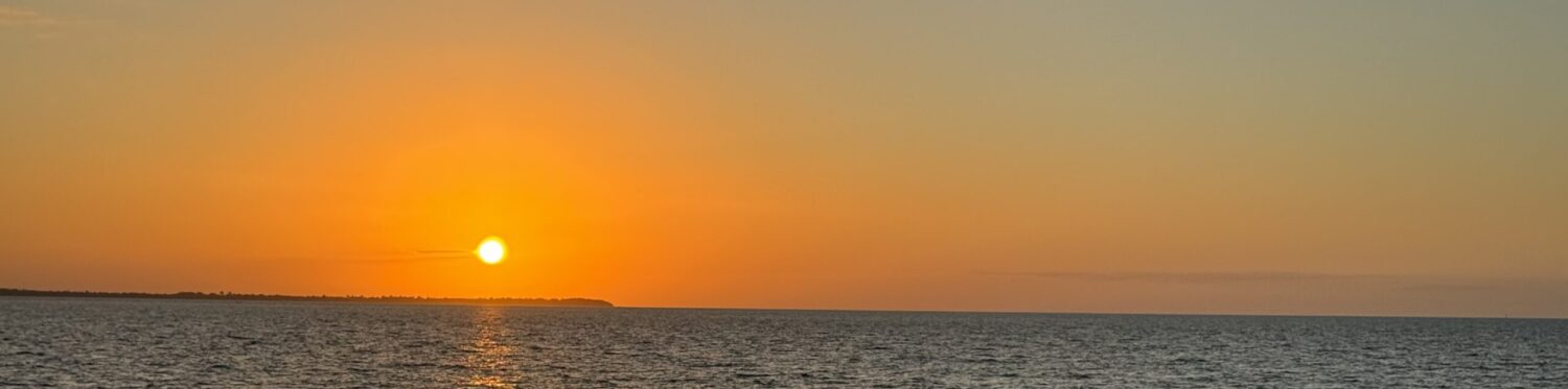
With a 6 am alarm we set a new record by leaving at 7:52am and saw lots of cattle everywhere on the road, as there has been most of our travels in northern Australia. Many of our stops are on stations with a tourist venture included and we have seen thousands of cattle along the road. Just hoping they stay on the roadside as we’ve also seen lots of dead ones, along with dead kangaroos. Another long driving day got us to Karumba, where we checked into a CP (caravan park), drove around the town and saw the famous Karumba sunset over the Gulf of Carpentaria while having a seafood dinner in the Sunset Pub.
Stopped in Normanton to take pictures of a model of the largest crocodile ever shot. Quite scary to imagine it! Then in another long driving day (410 kms)we stopped at the Burke & Wills Roadhouse (named after two early Australian explorers who didn’t make it back) before overnighting in a free camp at Gregory River. Re-met our Swiss friends here, and stupidly left a front van window open overnight so I was suffering badly from mosquito bites in the morning.
This drive we are doing is along The Savannah Way which goes from Cairns to Broome. With last years trip and this one we will have covered almost all of this iconic Australian road journey.
Black Mtn, outside of Cooktown
The Lions Den Hotel
Trevathan Falls
Bloomfield Falls, better known but not as special Cape Tribulation beach
Port Douglas lookout with Chris & Christine Lake Tinaroo campsite, near Atherton Amy’s Beach Ultimate team with their medals (Amy is 2nd from the left in the back row)
Mt Hypipamee Crater-volcanic vent hole, 124 m deep
Cassowary in the wild
Ellinjaa Falls Millstream Falls, the widest one in Australia
Lots of cattle on the road Inside the lava tubes
A view of Cobbold Gorge from the clifftops
A view of Cobbold Gorge from the water Brolgas at the side of the road A Karumba sunset and only the second place where we saw the Gulf of Carpentaria The colors kept changing in the sunset
Normanton – Model of the largest crocodile ever shot The story behind the crocodile Burke & Wills Roadhouse, in the middle of nowhere
The sign we are following A map showing The Savannah Way


")


